An advanced techno-economic assessment tool has been developed for 5G deployments
With the hotly anticipated rollout of 5G now taking place in many frontier economies, industry and government are seeking new decision support tools to help understand the capacity, coverage, and cost of 5G infrastructure deployment.
Many locations currently not served by cellular coverage (2G, 3G, 4G, 5G) are often the hardest to reach, making them challenging investments for mobile network operators. New analytics can help to provide greater investment certainty when deploying infrastructure in hard-to-reach places.
Often, telecommunication infrastructure decisions rely on simplified cost assessments using Excel spreadsheets, which can include a large amount of uncertainty. However, more advanced analytical models can require considerable technical skill to run and interpret, as they do not have graphical user interfaces. Additionally, there is not always a clear link between infrastructure decisions, quality of service metrics (e.g., Mbps per user), and the required total cost of ownership for new assets. Hence, these issues need to be overcome if we wish to provide new data analytics for decision makers, with the aim of enhancing existing levels of digital connectivity.
Over the past year, a new software capability has been developed for deployment on the UK’s new Data & Analytics Facility for National Infrastructure (DAFNI), funded via an £8 million investment from the UK Collaboratorium for Research on Infrastructure and Cities (UKCRIC). The beta version of the software is currently being used by academics and has a variety of use cases which include:
- Determining the key cost components in the roll-out of 4G and 5G under different capacity-expansion strategies, for different types of infrastructure assets (macrocells, microcells, and small cells).
- Quantifying the spatial implications of roll-out, including the cumulative cost of population and geographic coverage.
- Testing the performance of different strategies in meeting future demand.
- Exploring the costs per user across scenarios, strategies, and user types.
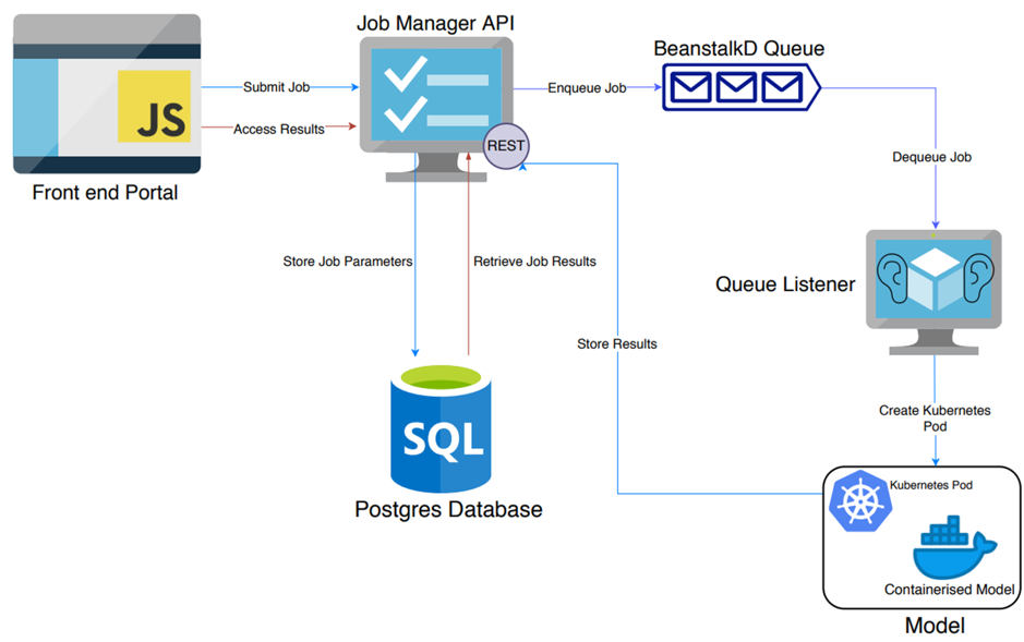
The software architecture includes a containerized Python digital communication assessment model, linked to a job manager Application Programming Interface (API). An SQL database then feeds data to a JavaScript web interface, which allows non-technical users to run the model. The software architecture is illustrated in Figure 1.
Figure 1 Software Architecture

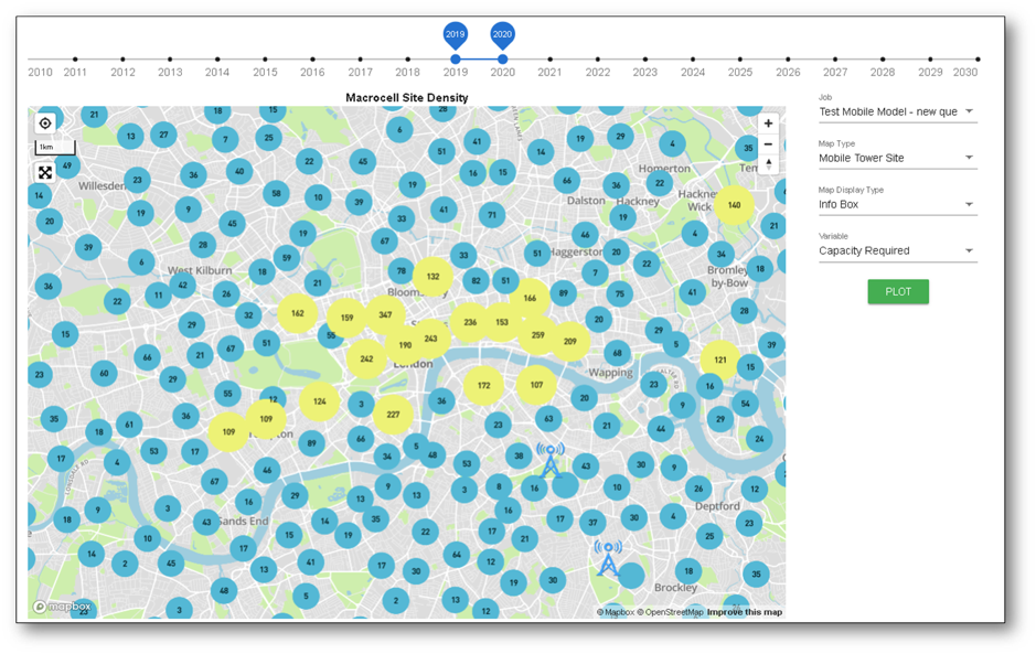
The results interface can visualize the existing level of connectivity geographically, including the locations and properties of current cells. Figure 2 illustrates the existing macrocell locations for central London.
Figure 2 Existing Macrocell Locations

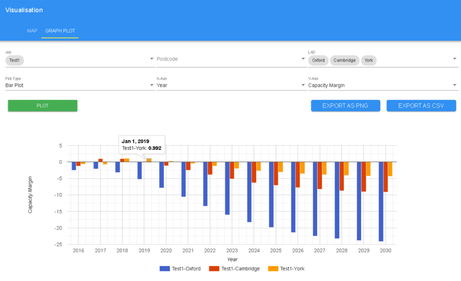
As well as visualizing data geographically, traditional two-dimensional (2D) plots can be used to assess the results. Figure 3 illustrates the capacity margin for the historic cities of Oxford, Cambridge, and York based on (i) quantifying future data demand given demographic and traffic growth in local statistical units and (ii) deploying new types of 4G or 5G capacity enhancing techniques (adding new spectrum or building more cells).
Figure 3 2D Bar Plot of Capacity by Local Authority

The model can be used for scenario planning, as well as providing spatial evidence for regulatory and policy options.
Different types of deployment strategies can be tested to quantify the potential capacity and coverage implications, from high-level scenario planning, down to detailed interference assessment of new cellular sites. This information is of great interest to many small and medium digital ecosystem players, who may have limited resources to develop their own planning capabilities.
The Cambridge Digital Communications Assessment Model is one of a number of new software models that will run on DAFNI.
About DAFNI
The aim of the Data and Analytics Facility for National Infrastructure (DAFNI) is to provide a secure platform for researchers to undertake cutting-edge infrastructure data science.
DAFNI is managed by the Science and Technology Facilities Council and is based at the Rutherford Appleton Laboratory on the Harwell Campus, Oxfordshire, UK. Using advanced computing, DAFNI provides world leading infrastructure systems research capabilities to collate infrastructure data from multiple sources, map and model it, and use advanced visualizations to demonstrate and explore scenarios.
DAFNI is funded by an £8 million investment from the UK Collaboratorium for Research on Infrastructure and Cities (UKCRIC) in 2017. It is recognized as critically important by over 100 signatories from the research community, business and government who are supporting a “Statement of Community Need” submission to request ongoing funding through the Engineering and Physical Sciences Research Council (EPSRC) for DAFNI to transition into the National Research Facility for Infrastructure Data, Modelling, and Simulation.
Edward Oughton is a Senior Research Associate at the University of Oxford. His research uses analytical techniques from engineering and computer science, to answer new questions pertaining to policy, innovation, planning, economics and sustainable development. Recently he has been producing evidence on effective strategies to connect more people to a faster internet. Such information is vital for ensuring sustainable economic development as most new technologies require internet connectivity. In total he has been awarded USD 766k of funding (PI on USD 180k, Co-I on USD 249k) from organizations including the UK Engineering Council, World Bank, Facebook, and the US, UK, Dutch and Canadian governments. Currently he has published 11 peer-reviewed first-author papers, was recently awarded ‘Best Paper 2019’ by the journal Risk Analysis, and was selected as a 2019 PTC Young Scholar. In 2017 he was nominated by the US Embassy for the International Visitors Leadership Program based on his digital infrastructure research. Edward holds an MPhil and PhD from the University of Cambridge.


